 |
 |
|||
|
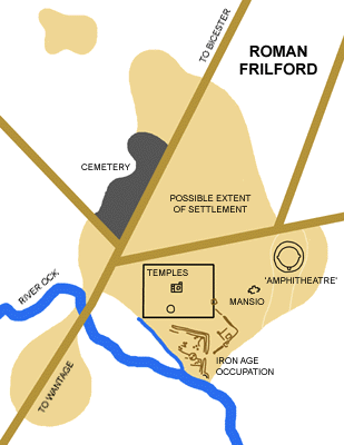 Roman Frilford Roman FrilfordPagan Religious Centre Introduction The well-known Roman settlement at 'Frilford' - it is actually just in the parish of Marcham - sits at a point where the Roman road from Bicester to Wantage crosses the River Ock, the centre of a network of smaller Roman roads and settlement sites, including a villa only about a mile to the north-west. Iron Age Occupation The settlement appears to have had its origins in the Middle Bronze Age, although evidence of substantial occupation only appears in the Iron Age period. Beneath the later Roman buildings have been found part of a stake-walled round house and a number of pits associated with early and middle Iron Age pottery. The occupation appears to have been domestic in nature and may have come to an end before late Iron Age since material from this time is lacking. The site was then probably abandoned for some years, although it is possible that an, as yet undiscovered, pagan religious building may have continued in use into the Roman period. Romano-British Temple 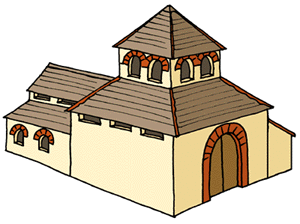
Around the late second century AD, a rectangular temple building of the common Romano-Celtic type was erected on the site, possibly succeeding an unlocated Iron Age shrine. In its initial form, it consisted of a square, probably open arched, cella surrounded by a narrow corridor (or less likely, a portico). It was decorated with painted wall plaster and tesselated pavements. In later times, possibly during the 4th century, a large aisled extension was added to the rear of the building and a small annex on one side. The entrance seems to have faced eastward, opening onto a paved path with at least three layers of metalling. A deposit of seventy-eight 4th and 5th century coins and other bronze items on the uppermost surface. may indicate possible usage into the post-Roman period. Round Temple About eighty-five feet to the south of the extended square temple, stood a stone-walled circular building or 'rotunda', with a square pit and a hearth within. The hearth probably had a religious significance, as found in other Romano-British temples, and was dated to the 2nd century by a pottery shard and a coin of Valentinian discovered there. The building was therefore probably contemporary with its square counterpart. Signs of burning throughout the interior suggest that it was eventually destroyed by fire. Temenos These two Roman temples were set within a sacred precinct or stone-walled 'temenos'. This has been examined through both aerial photography and subsequent excavation, although the western boundary is so far unlocated. The square temple was at the centre of the east-west axis of the temenos, with the rotunda just to the south. There may have been upwards of three other shrines also, but these have not yet been excavated. The whole seems to have been landscaped with trees and bushes whose trenches have been discovered scooped out of the bedrock beneath. The 'Amphitheatre' Nearly four hundred feet east of the temenos boundary wall has been found a large Roman structure now flattened and ploughed over. It is approximately circular, about two hundred and thirteen feet in diameter, built into a narrow dry valley running south to the River Ock. The arena was surrounded by stone wall and a bank about thirty-five to forty feet wide. There was an small projecting annex to the south, while the entrance was probably on the eastern side. This unusual structure has been interpreted as either an amphitheatre or a walled enclosure for a sacred pool. Both archaeological and literary evidence indicates a clear association between acting, religious festivals and the gods. Roman theatres therefore had strong religious connotations and were often associated with temples. Similar evidence is lacking for the usually military amphitheatres, although the Frilford example could have been a crude replacement, fulfilling the same range of functions as the typical Gallic theatre. It is certainly circular rather than the more usual ellipse. The annex could have been some sort of viewing platform, a beast-cage or, perhaps most likely in this context a small shrine. Recent excavations, have cast doubts on whether the surrounding bank could have supported spectator seating; while bronze, glass and bone finds at the back of the bank seemed to have been ritually deposited. Most of all the interior appears to have been rather overly damp for an arena supporting religious activities; so much so that the plaster on the retaining walls appears never to have been applied to the lower levels. It has therefore been suggested that this was, in fact, a walled sacred pool, as sometimes found in Gaul. The Mansio Almost exactly half-way between 'amphitheatre' and temple temenos has been excavated a eats-west aligned building of several rooms. It had stone foundations in shallow trenches, suggesting that the majority of the upper structure was of wooden beam construction. The interior was roughly paved with both tile and stone and revealed numerous finds, largely coins from the 3rd and 4th centuries AD. It was probably a mansio or lodging house for the many pilgrims who must have visited the adjoining temples and shrines. The Cemetery Like modern churches, this religious complex appears to have been a magnate for the burial of the devoted, for, situated four hundred and fifty feet north-west of the temples was a late Roman cemetery which extended its use into the early Saxon period. A total of three hundred and fifty-nine plus graves have been excavated here. Some of the late Roman occupants laid in lead coffins, wore hob-nail boots, and had coins in their mouths to pay the ferryman to the underworld. Anglo-Saxon burials included both inhumations and cremations, revealing a range of associated 5th and 6th century artifacts. There was almost certainly a period of overlap between burials of these two communities. Function & Status As well as being a natural geographic boundary, there is considerable evidence to suggest that the Vale of the White Horse, where Frilford stands, was also, from the first millennium BC, some kind of demographic boundary and cut-off point for the distribution of various items of material culture. Prehistoric and Roman settlements are prolific on both the Corallian Ridge to the north and the chalk Berkshire Downs to the south; but the clay soils of the Vale itself were largely unsettled. It seems to have formed an unpopulated divide, probably between two tribal regions, for, in the Iron Age, the boundary between the southern Atrebates and the midland Dobunni is known to have lain somewhere in this region. A not uncontroversial theory exists which suggests that such tribal boundaries in Gaul were often the locations of religious complexes. Thus each tribe was able to assert its cultural identity in a region where alternative ways of life were also influential. Though the whole Vale should probably be taken as a no-man's land between tribal kingdoms, the River Ock might represent a more specific border. Roman Frilford therefore stood just on the Dobunnic side and may have been founded to counteract the Atrebatic religious centre at the White Horse itself, just fifteen miles up the valley.
|
|||
| © Nash Ford Publishing 2003. All Rights Reserved. This location is now administered by Oxfordshire County Council. | ||||